Volcanoes aren't the only
scenery along this byway, where you can also
experience the beauty of Old Perpetual, Oregon's
only geyser, or see the snow-covered ridges of
Abert Rim. Visit some of the various lakes of
the area, such as Abert Lake, where a palette of
desert colors are reflected in the alkaline
waters. You can hike trails, unravel the
mysteries of petroglyphs, or bike the quiet
country roads at Summer Lake. Walk along the
paths of the past by visiting Newberry Crater,
which was home to Native Americans some 10,000
years ago, or when you go through Picture Rock
Pass, imagine the hands that engraved the
petroglyphs thousands of years ago.
With
beautiful scenery and geologic wonders, take the
chance to experience this unique drive along the
"outback" of Oregon. See the Lava and Landmarks
along the Outback Scenic Byway. Step out of your
car at any given point on the Outback Scenic
Byway, and you will be startled by the
ever-changing landscape. Transitioning from
forests and lakes to sagebrush and desert, the
Outback Scenic Byway offers an awe-inspiring
view of the diverse nature and landscapes of
southern Oregon. Round up the family and head
out on this resplendent northwestern drive for
an unforgettable encounter with nature.
Hole-in-the-Ground -Travel
about 20 miles south from the byway’s beginnings
in La Pine and then go about 10 miles east off
the byway. Here you’ll find a giant bowl-like
formation in the landscape, known as
Hole-in-the-Ground. While some mystery surrounds
this interesting landmark, it is most commonly
recognized as the result of volcanic activity.
Measuring at about 4,500 feet east to west and
5,500 feet north to south, this crater is a
must-see. Stop and explore this 300-foot-deep
dish-like crater-- you'll marvel in its sheer
magnitude!
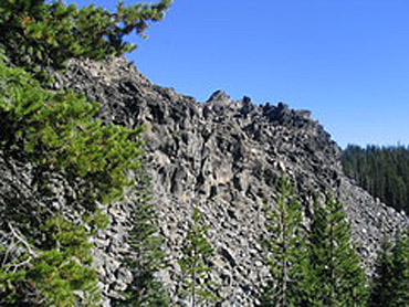
Devil’s Garden
- For more striking evidence of
volcanic activity, travel about 10 miles
southeast of Hole-in-the-Ground and 20 miles
east of the byway to Devil’s Garden. You and
your family will love exploring this lava flow
that left a system of lava tubes behind. Stand
near the site and notice how porous and light
the lava rocks are. Picture what the landscape
could have been like millions of years ago.
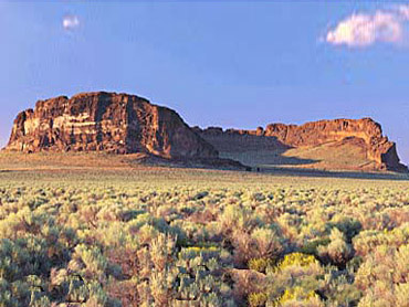
Fort Rock - For more volcanic
excitement, drive along the byway about 10 miles
southwest of Devil’s Garden and then go about 5
miles east from the byway. You’ll see miles of
sagebrush until suddenly a giant rock formation
stands before you, a solitary peak in the
surrounding flatlands. This marvel, known as
Fort Rock, is a crater from a dormant volcano
and has been designated a National Natural
Landmark. To really experience this
325-foot-high tower, enjoy a picnic or a day
hike on any of the trails near the crater.
Complete your Fort Rock adventure with a stop at
the nearby old Fort Rock Homestead Village, a
quaint ghost town filled with buildings that
date back to the 1800s. Pay a visit to the Fort
Rock Valley Historical Homestead museum and
learn about the captivating history of these
buildings and the Fort Rock area.
Crack-in-the-Ground - From Fort
Rock, head about 30 miles east, just above
Christmas Valley, and you will see a truly
unusual landmark known as Crack-in-the-Ground.
Cracks and fissures like Crack-in-the-Ground are
common results of volcanic activity or
earthquakes, and most fill quickly with magma or
rubble. However, this is not the case for
Crack-in-the-Ground-- this fascinating fissure
has been open for about 1,000 years! Spend a few
hours exploring and hiking this 2-mile-long
chasm. You can even hike on the bottom of the
crack—some places reach depths of 70 feet with a
width of only 10 to 15 feet.
Rock Pass- While considering the long
history of this area, visit Picture Rock Pass,
about midway along the byway, 20 miles south of
Crack-in-the-Ground. See evidence of past
civilizations in the many pictographs on the
surrounding rocks. Study these images and
imagine Oregon natives leaving their mark on the
world 12,000 years ago-- the age of some of the
drawings. Capture these pieces of art with your
camera, but be careful not to touch them.
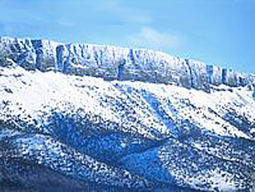
Abert Rim - Drive further
south along the byway to the Abert Rim, a
30-mile fault escarpment just east of Lake
Abert. The ground level has been broken and
elevated here, due to plate tectonics. Rising
2,000 feet above the Outback Scenic Byway, Abert
Rim is a giant compared to the flat land you’ve
been driving. Looking to stretch your legs? Try
hiking around Abert Rim on one of the many
trails that vary in length and elevation. Plan
the perfect day hike, as there are no developed
campgrounds in the area.
Old
Perpetual Geyser - As you near the end
of the byway, stop at Oregon’s only continuously
spouting geyser, Old Perpetual. This waterspout
shoots a tower of 200-degree water 60 feet in
the air every 30 to 90 seconds. As the only
geyser of its kind in the Pacific Northwest, Old
Perpetual is truly an anomaly. Take a short walk
from Old Perpetual to another watery wonder
known as the Hot Springs. Relax in water from
this geyser and, according to local legend, you
may be healed of whatever malady you may have.
The sun falls on another cool Oregon day as
your byway journey comes to an end. From
astounding landmarks to rich history to soothing
hot springs, this one-of-a-kind Oregon
experience will have you planning your next trip
on the Outback Scenic Byway as soon as you
leave!

Photo Credits:
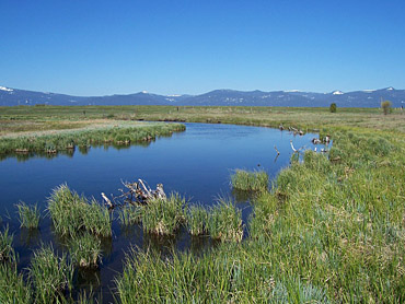
Photo1 Crooked Creek by
Natural Resources Conservation Service.
Photo 2
Fort Rock by Parks Dept.
Photo 3 Abert Rim Snow by Lake County Chamber.
Photo 4 Devil's Rock by Brett Hansen.
Information Courtesy of National Scenic
Byways Online.
Add More Information!
We Can Add More Information to
this page,
Click Here and supply
your text info and we will add it in!
BACK TO BYWAYSThis
is a general information page. All byway profile information on is
provided to users on an "as is" and "as available" basis without
warranty of any kind either express or implied. Always verify any driving
directions. We are not responsible for any diving
misdirections or info, if any, on this page. See
terms
page if needed.