COW LAKES

Your Southern Oregon Guide

UPPER & LOWER LAKE

  • cow lake

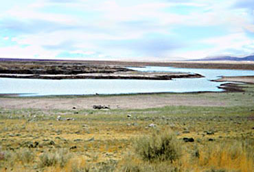
The Upper Cow Lake and Lower Cow Lake are located in Malheur County in Southeast Oregon, approximately 15 miles west-northwest of Jordon Valley. These are flat, playa lakes, that were formed when the Jordon Craters lava flow blocked stream flows. The area contains large areas of open water and emergent vegetation. Exposed mudflats are present in late summer. Large numbers of moist soil dependent plants are present. This cluster of lakes and marshes regularly has several thousand waterfowl and over 100 shorebirds in season (Marty St. Louis pers. comm.).

In addition, several dozen pairs of Black-crowned Night-Herons breed in dense marshes in the Batch L. complex near Cow Lakes (Contreras and Kindschy 1996). The Cow Lakes area is also considered important as a Shrub-Steppe Bird Conservation Area (Altman and Holmes 2000). Conservation Issues Enforcement of existing land use policies on BLM land may be inadequate: too many cattle too long, ORV use is high. Exotic plants are common at this site.

Contacts Bureau of Land Management
Vale District Office
100 Oregon Street
Vale, OR 97918

The geological background of this province is based in volcanic activity which started in the Miocene. There are deep volcanic deposits of basalts, tuffs and tuffaceous sediments. While basalt is prevalent, other features include rhyolite, diatomaceous deposits, new sedimentary deposits and new surface lava. The episodes of deposition affecting the Owyhee uplands include the Owyhee Basalts that erupted onto the plateau 13-12 million years ago and the ash-flow tufts from the Steens mountains around the same time. In a few areas there has been relatively recent volcanism, of special note is Jordan Craters.
The Jordan Craters lava flow is located in the Owyhee uplands on the plateau. It is a 75 square kilometer olivine basalt flow that is extremely recent by geological time. Potassium argon (K-Ar) dating shows that it is no older than 30,000 years. However, "studies based on growth rates of lichen and weathering rates of exposed and unexposed basalt suggest that the flow may be between 4,000 and 9,000 years old". "Additionally the southeasterly flowing lava altered ancestral drainage patterns, giving rise to a natural dam and the formation of two small lakes (Upper and Lower Cow Lakes)"

For more info See Malheur County Website at: www.malheurco.org

Add More Information!
We Can Add More Information to this page, Click Here and supply your text info and we will add it in!
 
BACK TO LAKES PAGE
 
This is a general information page. All lake information on is provided to users on an "as is" and "as available" basis without warranty of any kind either express or implied. SouthernOregon.com is not responsible for any change in lake information, conditions, amenities, misprint, hours or directions. See terms page to read more user details.