Special Rules

Motorized vehicles
and equipment are prohibited. In addition,
hang-gliders, carts, wagons, bicycles and other
forms of mechanized transport are not allowed
(disabled persons in wheelchairs permitted.).
Maximum group
size is 8 persons; maximum number of stock per
group is 12 pack/saddle animals.
Campsites must be
at least 100 feet from lakeshores and 50 feet
from streams. Keep pack and saddle animals at
least 200 feet from lakeshores and 50 feet from
streams. There are no developed or improved
campsites in Sky Lakes.
Avoid tying
animals to any live tree; doing so wears off the
bark and exposes roots, which eventually kills
the tree. Instead, use a "high-line" stretched
tightly between two trees.
Be sure to bring
adequate food (pellets or grain, not hay) for
your animal because feed is scarce in the
Wilderness.
Grazing is not allowed before August 1, unless
otherwise posted at trailhead bulletin boards.
Avoid specially
marked "restoration sites".
So that everyone
may enjoy the tranquility of the Wilderness,
refrain from operating loud radios or other
audio devices. Discharging of firearms within or
near occupied areas or across lakes is
prohibited.
The Wilderness
contains two lake basins (Seven Lakes Basin and
Blue Canyon Basin) where further restrictions
apply:
In sensitive areas of these two
basins, groups with pack/saddle animals must
camp only within designated "horse camp" sites.
These sites are marked with signs; sensitive
areas and horse-camp locations are shown on maps
posted at trailheads.
In the two basins,
grazing is permitted only in designated meadows
and only after August 1 (unless otherwise posted
at trailhead bulletin boards).
Be sure to
check the trailhead bulletin board for current
rules and other information pertaining to the
Sky Lakes Wilderness. The complete management
regulations enforced in the area may be reviewed
in the Forest Supervisor or District Ranger
offices.
GeologyIn terms of
geologic time, the Sky Lakes Wilderness is quite
young. Its volcanic and glacial history is
clearly written in landforms as well as rocks
and soil.
Geologic studies indicate that
the earliest rocks in this part of the High
Cascades began forming when a chain of volcanoes
erupted between five and three million years
ago. During the "Ice Age," the composite
volcanoes of Mount Mazama and Mount McLoughlin
began their initial build-up less than one
million years ago. Just south of Sky Lakes,
Brown Mountain produced its extensive lava field
as late as 20,000 to 15,000 years ago, and the
last eruption of Mt. McLoughlin took place
around the same time.
On their north and
east slopes, Mt. McLoughlin and other peaks bear
the scars of glacial ice. Like most other major
drainages within Sky Lakes Wilderness, Seven
Lakes Basin and the deep canyon of the Rogue
River's Middle Fork were carved by the massive
ice fields which covered the highest elevations
of the Cascades.
With the onset of warmer
climate, local glaciers virtually disappeared by
12,000 years ago. Volcanic activity was not yet
over, however. Minor lava eruptions and
mud-flows occurred at places like Big Bunchgrass
Butte and Imagination Peak. A chain of cinder
cones, extending from Goosenest Mountain north
to present-day Crater Lake National Park, also
formed during the post-glacial period. The most
recent--and by far the most
catastrophic--geologic event happened about
6,700 years ago, when Mt. Mazama exploded and
collapsed, forming the caldera of Crater Lake.
Some of the vast amount of rock and ash which
was thrown into the air landed in the northern
portion of Sky Lakes Wilderness, creating the
pumice-covered "Oregon Desert."
Although
forests now carpet much of its terrain, Sky
Lakes Wilderness retains its character as a land
derived from "fire and ice."
VegetationOn the timbered slopes are found many
species of trees and smaller plants. Nearly two
dozen tree species exist, ranging from the
Pacific yew in the lowlands to the mountain
hemlock and subalpine fir in the higher places.
Lodgepole pine is commonly found, but is in its
element in the Oregon Desert. Whitebark pine, an
uncommon tree in Sky Lakes, may be found high on
the slopes of Mt. McLoughlin. Shasta red fir
dominates much of the Wilderness.
Numerous shrubs, ground-covering plants, and
wildflowers occur in Sky Lakes. Special
attention should be paid to the prostrate
juniper and heather in the rocks above
Margurette Lake, the brilliant columbine amid
the talus rock of Lucifer, and the kinnikinnick
and huckleberry found in many places throughout
the wilderness.
WildlifeYou may
encounter any of the wild creatures common to
the Cascade Range as you travel Sky Lakes. You
may see chipmunks, a family of deer, or even a
herd of elk. Possibly a black bear will visit
your camp or a coyote will fill your night with
his lonely music. Uncommon animals in the area
include the yellow-bellied marmot, the fisher,
and the pine marten. Often heard (but rarely
seen) among the rocks of talus slopes is the
tiny pika.
Eagles and other large hawks
may be seen as they pass through. Goshawks live
and hunt under the tree canopy. The area
provides them with an excellent environment in
which to nest and rear their young.
ClimateSummers at this latitude tend to
be warm and dry, while winters at this high
elevation are bitterly cold and produce a heavy
snow layer. The snows often prevent free access
through the area until mid-July. On protected
north slopes on Mt. McLoughlin and Devils Peak
snow may persist to the end of summer.
Except for an occasional summer thunderstorm,
there is normally little moisture from June to
October. The fragility of plants and
soils is directly related to the climatic
patterns. The growing season between the thaw
and the drought is extremely short.
HistoryBeginning several thousand years
ago Native American groups--ancestors of the
Klamath and the Takelma Indians--hunted game and
gathered huckleberries within the Sky Lakes
area. Klamath youths would sometimes come to
make their "vision quest" (a religious
experience during which one fasted in solitude
and sought a spiritual vision while dreaming) on
high peaks along the Cascade crest. However, the
short season of mild weather and the limited
variety of food plants and animals did not
encourage prehistoric visitors to stay long.
The early white settlers also made use of
the Sky Lakes--hunting, trapping beaver or
marten in the winter, grazing their stock (in
the early days, large herds of sheep) in the
high meadows during the warm months. Settlers
from lower-elevation communities came each
August to pick huckleberries at places like
Stuart Falls and Twin Ponds. After 1906 the
newly established Forest Service built trails
and fire lookouts within the Sky Lakes area. By
mid-1970s, a new Pacific Crest Trail route
replaced the original Oregon Skyline Trail of a
half-century earlier.
Points of
Historical Interest. The Sky Lakes Wilderness
contains evidence of use by previous
visitors--from the stone tools of prehistoric
Indians to 20th century cabins and shelters.
These cultural resources are protected by law
for public enjoyment and education; please do
not remove, disturb or destroy these gifts from
the past.
The Twin Ponds Trail
follows
the route of the old Rancheria Trail, an Indian
travel route. In 1863, it was widened and used
as a military wagon road between Jacksonville
and Fort Klamath. This portion of the Rancheria
Trail is listed on the Nation; Register of
Historic Places; many segments of the old wagon
route are visible to the discerning eye along
the Twin Ponds Trail.
At the southeast
end of Island Lake is the Waldo Tree. This
inscribed Shasta red fir bears the carved names
of early-day Oregon conservationist Judge John
B. Waldo and four companions. In 1888, these men
journeyed south along the crest of the Cascades,
from Waldo Lake to Mt. Shasta, the first
recorded party to travel much of the general
route of what is now the Pacific Crest Trail.
Pacific Crest TrailHikers and
horsemen will find a well constructed, well
maintained Pacific Crest Trail winding along 35
miles of the summit of the Cascade Range through
the Sky Lakes Wilderness. A trailhead on Highway
140, a mile east of Fish Lake, is the southern
entrance point. The trail passes through lake
basins and over ridges on its way north, where
it crosses into Crater Lake National Park. The
Pacific Crest Trail may be reached from other
locations by way of the many other trails that
enter the Sky Lakes Wilderness.
Maps of
the Pacific Crest Trail through Oregon are
available at Forest Service offices.
Planning Your TripA hiker in good
condition will average a maximum of 10-15 miles
per day. Those not used to hiking should not
plan on more than 5 to 10 miles.
There
are no stores along the way from Fish Lake or
Lake of the Woods resorts to Crater Lake Lodge.
Side trips to supply points in Butte Falls,
Rocky Point, Prospect, or Fort Klamath are not
considered reasonable unless you have a vehicle
at the trailhead.
Don't plan to live off
the land. Survival foods do not exist in
abundance. Berries are seasonal. Fishing can be
poor much of the season. (Oregon fishing
licenses are required.)
Permits and FiresNo permit is required provided that your
group totals less than 8 people and 12 horses
and pack animals. Remember that large groups are
not compatible with the No Trace ethic and can
be destructive without intending to be. A group
of eight, for example, would often have to split
into two groups of four to avoid damage to
vegetation surrounding a potential campsite.
Normally, you will not need a campfire
permit. However, during unseasonably dry
weather, campfires have in the past been
prohibited. Keep your firepit small and take it
apart when you leave. Scatter the cold ashes
away from the campsite. It is possible to leave
no sign of your fire. Firewood is scarce around
many of the most popular lakes. A light-weight
gas or propane stove of the backpacking variety
is a handy item.
Motorized Use
Motor vehicles and motorized equipment such as
chainsaws are
not allowed. Also, mountain bikes
are prohibited.
CampingThere are
no developed or improved campsites in Sky Lakes.
Remember that camping is not allowed within 100'
of any lake or pond. Older camp spots from years
past can be seen very close to lake shores. Do
not be tempted to use these. Over time it is
hoped that vegetation can be restored on these
sites so that the shores of popular spots do not
become deserts.
Wilderness RangersWilderness rangers patrol the Sky Lakes area
daily. Their job is to help visitors to
understand the unique problems which increasing
recreational use brings to our wildlands. They
also love to swap stories about the wildlife and
history of the area. They do not enjoy having to
enforce rules which exist for the common good.
FishingMany of the nearly 200 lakes
in the area are shallow and do not support fish,
but the deeper lakes may have some brook trout.
A few lakes may have rainbow trout. The South
and Middle forks of the Rogue River and Red
Blanket Creek also provide fishing. An Oregon
State fishing license is required.
HuntingGeneral hunting seasons are in
accordance with the Oregon State Fish and Game
Department regulations. Oregon hunting licenses
and appropriate game tags can be obtained at
most sporting goods stores in Oregon. Outside of
hunting season, firearms are permitted, but
discharging them is discouraged due to the
obvious nuisance effect created where peace and
tranquility are the expectations of users.
StockThere are few meadows and very
little grazing in the lake basins. We recommend
from 12 to 18 pounds of pellets per head per
day. To protect lakeshore vegetation, pasturing
or tethering of stock within 200' of any lake is
prohibited. Tie horses to a hitchline strung
high enough between two trees to allow them to
pass under. Set up you hitchline where damage to
vegetation will not occur. A shovel may be used
to scatter manure and keep flies down.
PestsRattlesnakes are not known to occur
in Sky Lakes. Mosquitoes can be very bad through
midsummer. Bears are only rarely a problem.
There is no poison oak or ivy.
WildflowersDepending on conditions from
year to year, the most spectacular wildflower
displays occur in July or early August. The best
huckleberry picking is in late August.
Rock ClimbingRock climbing is not
considered an attraction in Sky Lakes.
Emergency ConsiderationsThere are not
established search and rescue organizations in
the vicinity. Forest Service patrols may be
encountered anywhere in the area, but they
cannot be located at any fixed stations.
Sky Lakes Wilderness"Let us permit
nature to have her way; she understands her
business better than we do."
- Michael de
Montaigne (1533 - 1592)
Introduction
The United States Congress designated the Sky
Lakes Wilderness in 1984 and it now has a total
of 113,590 acres. All of the wilderness is in
Oregon and is managed by the Forest Service.
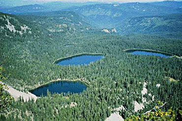
DescriptionWith a name like Sky Lakes,
this Wilderness is obliged to deliver at least
more than one impressive sapphire pool, and it
does. In fact, it takes in three major lake
(former glacial) basins as it stretches along
the crest of the volcanic Cascade Mountains from
the border of Crater Lake National Park on the
north to State Highway 140 in the south: Seven
Lakes, Sky Lakes, and Blue Canyon basins. All of
southern Oregon seems to lay at your feet when
viewed from the rugged summit of the beautiful
volcano Mount McLoughlin (elevation 9,495 feet),
and then extends out northward into Sky Lakes'
broad plateau-like ridges, dotted with many of
the Wilderness's lakes. You'll find creeks and
ice-cold springs (such as Ranger Springs, where
the Middle Fork of the Rogue River springs to
the surface almost "full-grown" from the beneath
the lava), grassy meadows, and scores of
crystalline sub-alpine lakes. Several of the
Wilderness's lakes (Alta and Natasha among them)
were found (by 1980s-90s Environmental
Protection Agency baseline study of acid-rain
conditions in Western U.S. mountain lakes) to
have among the most chemically pure water known
of all lakes on the globe. Most of the area's
lakes (some of them stocked by the State of
Oregon with game fish) are set against a
backdrop of tall trees that reach to the edge of
the lakeshore.
An overall high-elevation
forest consisting largely of Shasta red fir,
western white pine, and mountain hemlock yields
to lodgepole pine around many of the lakes, as
well to moisture-loving Engelmann spruce here
and there. Hardy, long-lived whitebark pines are
found near the summits of Mt. McLoughlin and
Devil's Peak. The forest's understory is
dominated by species of huckleberry, as well as
manzanita, snowbrush, and heather.
Elk
herds spend much of the summer and early fall in
the northern third of the Sky Lakes Wilderness,
and the elk-hunting season can be very active;
the entire wilderness supports roving
populations pine martens and fishers, black
bears, cougars, coyotes, as well as pikas and
golden-mantled ground squirrels and other
species of wildlife. During October and
November, migrating birds pass over in the
hundreds of thousands, often stopping at the
high lakes. Ospreys regularly visit Sky Lakes to
try their luck at fishing. Thirsty swarms of
mosquitoes hatch from snowmelt until mid-August.
The Pacific Crest National Scenic Trail
(PCNST) passes the entire length of Sky Lakes
Wilderness north-south for about 35 miles, but
much of the PCNST route is well away from
streams, springs, and other water sources. Human
use is heavy in the three main lake basins,
particularly at the larger lakes, which are
popular fishing, hiking, and camping
destinations. The 1888-inscribed "Waldo Tree,"
at the southeast shore of Island Lake is a draw
for a few historically minded visitors each
year, as is the opportunity to hike along the
route of an 1860s-1890s military wagon road, on
the present Twin Ponds Trail. The summit of Mt.
McLoughlin is a popular but very strenuous
summer day-hike. Other areas of the Wilderness
typically provide excellent opportunities for
solitude.
The Sky Lakes Wilderness is
part of the 107 million acre National Wilderness
Preservation System. This System of lands
provides clean air, water, and habitat critical
for rare and endangered plants and animals. In
wilderness, you can enjoy challenging
recreational activities like hiking,
backpacking, climbing, kayaking, canoeing,
rafting, horse packing, bird watching,
stargazing, and extraordinary opportunities for
solitude. You play an important role in helping
to "secure for the American people of present
and future generations the benefits of an
enduring resource of wilderness" as called for
by the Congress of the United States through the
Wilderness Act of 1964. Please follow the
requirements outlined below and use Leave No
Trace techniques when visiting the Sky Lakes
Wilderness to ensure protection of this unique
area.
General
Wilderness ProhibitionsMotorized equipment
and equipment used for mechanical transport is
generally prohibited on all federal lands
designated as wilderness. This includes the use
of motor vehicles, motorboats, motorized
equipment, bicycles, hang gliders, wagons,
carts, portage wheels, and the landing of
aircraft including helicopters, unless provided
for in specific legislation.
In a few
areas some exceptions allowing the use of
motorized equipment or mechanical transport are
described in the special regulations in effect
for a specific area. Contact the Forest Service
office or visit the web sites listed on the
'Links' tab for more specific information.
These general prohibitions have been
implemented for all national forest wildernesses
in order to implement the provisions of the
Wilderness Act of 1964. The Wilderness Act
requires management of human-caused impacts and
protection of the area's wilderness character to
insure that it is "unimpaired for the future use
and enjoyment as wilderness." Use of the
equipment listed as prohibited in wilderness is
inconsistent with the provision in the
Wilderness Act which mandates opportunities for
solitude or primitive recreation and that
wilderness is a place that is in contrast with
areas where people and their works are dominant.
Sky Lakes Wilderness Specific
RegulationsWilderness managers often need to
take action to limit the impacts caused by
visitor activities in order to protect the
natural conditions of wilderness as required by
the Wilderness Act of 1964. Managers typically
implement 'indirect' types of actions such as
information and education measures before
selecting more restrictive measures. When
regulations are necessary, they are implemented
with the specific intent of balancing the need
to preserve the character of the wilderness
while providing for the use and enjoyment of
wilderness.
Equestrians are welcome in
Sky lakes Wilderness, which offers many miles of
day-riding or overnight-packing opportunities.
However, with its fragile ground-cover
vegetation and short growing season, special
measures must be taken by stock users while in
the Wilderness to protect the area's
naturalness. Also, because of ecological and
social issues, in two of the high-use lake
basins of Sky Lakes (the Seven Lakes Basin and
the Blue Canyon Basin), designated horse-camps
must be used by equestrians when camping in
these two areas. The "Horses and the Sky Lakes
Wilderness" brochure provides details on these
camps as well as many other items of interest to
horse users.
The following wilderness
regulations are in effect for this area. Not all
regulations are in effect for every wilderness.
CACHING OF EQUIPMENT PROHIBITED
No
caching of food, supplies, equipment.
CAMPSITE RESTRICTION IN DESIGNATED SITES ONLY
Restriction of camping within designated
camps only applies within two high-use
lake-basin areas within the wilderness, as shown
on public hand-out map.
CAMPSITE
RESTRICTION IN MANDATORY SETBACK FROM WATER: 100
FEET
Campsites and fires prohibited within
100 feet from lakes; 50 feet from streams or
springs; preserves water quality, vegetation,
and privacy of other groups.
MAXIMUM
GROUP SIZE: 8 MEMBERS
Group-size limits
applied to provide for the mandated
opportunities of wilderness solitude.
MAXIMUM NUMBER OF STOCK: 12 HEARTBEATS
Number of stock permitted (12) provides for up
to 8 people to ride and use pack animals during
a wilderness visit.
STOCK USE
RESTRICTION MANDATORY SETBACK FROM WATER: 200
FEET
Protect water quality, vegetation, and
privacy of other groups.
STOCK USE
RESTRICTION NO HITCHING OR TETHERING: 200
FEET
Prohibits tethering stock to live tree
for more than 1 hour; prevents spread of barren
soil areas and girdling of trees.
For More
Information Contact: Fremont-Winema
National Forests
Klamath Ranger District
1936 California Avenue
Klamath Falls, OR
97601
(541) 885-3400
Klamath Falls
Work Center
2819 Dahlia Street
Klamath
Falls, OR 97601
541-883-6714
For Info, Dates, Fees visit:
www.fs.fed.us/r6/frewin/
Add More Information!
We Can Add More Information to
this page,
Click Here and supply
your text info and we will add it in!
BACK TO LAKES PAGE This
is a general information page. All lake information on is
provided to users on an "as is" and "as available" basis without
warranty of any kind either express or implied.
SouthernOregon.com is not responsible for any change in lake
information, conditions, amenities, misprint, hours or
directions. See
terms page to read more user details.