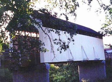
Year Built: 1922
Bridge Length: 58'
County: Jackson
Photo by Pat Cook
The bridge
originally spanned Antelope Creek some 10 miles
southeast of Eagle Point. In August 1987, the
structure was loaded onto a makeshift trailer
and volunteers hauled it to the City of Eagle
Point.
When the bridge
was rebuilt at the new site, arched openings
were cut into each side so school children could
be watched as they crossed the span. This
alteration caused the bridge to be removed from
the National Register of Historic Places. Since
then, the bridge has been re-sided in a fashion
that represents the original design. Now only
ribbon openings appear under the eves.
Location
World Guide#
37-15-02
Latitude:
N42 28.32
Longitude:W122 48.00
Driving Directions
From
Highway 62 in Eagle Point, turn east onto Linn
Road (sign points to Eagle Point and Klamath
Falls). Travel to South Buchanan Street and turn
left. Turn right onto West Main Street and
continue to Royal Avenue. The bridge is located
in the city of Eagle Point at the intersection
of Main Street and Royal Avenue.
Information provided by: Covered Bridge Society
Of Southern Oregon..
Always Verify Driving
Instructions.
Add More Information!
We Can Add More Information to
this page, Click Here and supply
your text info and we will add it in!
SouthernOregon.com
does Not provide Directions and Info by phone.
BACK TO COVERED BRIDGES
This
is a general information page. All profile information on is
provided to users on an "as is" and "as available" basis without
warranty of any kind either express or implied. See terms
page if needed.