Don Porter Covered Bridge in Southern Oregon  
DON PORTER COVERED BRIDGE -  Josephine  County - Southwest Oregon
 

Bridge Length = 36'
Built: 1980
Photo by Ken Ritz.
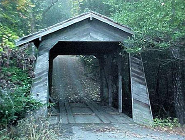
Although Newer Built and not recognized to some, we thought we would place it in.
 
LOCATION
World Guide# 37-17-A
Latitude: N/A
Longitude: N/A

MAP (Approx)

Across Limpy Creek west of Grants Pass. US199 west 9.3 miles from jct with I5 exit 55 on the east side of Grants Pass, north (curves around & winds up going west) on Riverbanks Rd. 4.5 miles, continue west on Limpy Creek Rd. (CR3620) about 1.9 miles to the bridge on the N. side of the road at 1800.

 << Back To Previous Page  ][  To Top of Page ^  ][  To Covered Bridges Page

Add Your Information!
To Add More Information to this page, Please Use this Free
"Add More Info Form"
For Business Listings please use the Contact Us link.


Covered Bridges in Southern Oregon features covered bridges, drives,  road trips in southern Oregon and coast, Applegate Valley, Rogue Valley, Klamath, Roseburg,  Illinois Valley and all areas in Southwest, southwest eastern Oregon area for southern oregon, covered bridges, covered bridges in, rogue valley, umpqua hwy 138, roseburg, oregon coast hwy, bridge, grants pass covered bridges, medford covered bridges, talent covered bridges, oregon, applegate valley, ruch, talent covered bridges, ashland covered bridges, klamath falls covered bridges, lakeview covered bridges, bridge, oregon coast covered bridges, brookings,  jackson county covered bridges, josephine county covered bridges near towns in oregon
 TERMS OF USE / PRIVACY POLICY
 
SITE MAP
Real Estate - Lodging Southern Oregon - Businesses - Activities & Recreation - Attractions - Home
Shopping Gifts Collectibles in Southern Oregon Map - Lakes - Local cities area info Media TV Radioguide climate

Designed by southernoregon.com and rogueweb.com

Thank You for Visiting Southern Oregon Directory & Guide