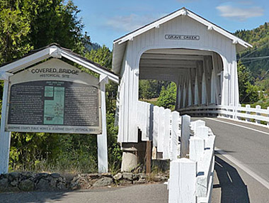
Built in: 1920
Bridge Length: 105'
County:
Josephine
The Grave Creek Covered
Bridge is one of the few covered bridges that
remain in southern Oregon. From Vancouver B.C.
to the Mexican border, it is the only one
visible from the I-5 freeway. Be sure to visit
the Applegate Trail Interpretive Center while in
Sunny Valley. It provides a first hand look into
the local area, history, fabulous displays,
theatre & more.
In the fall of 1846,
the first emigrant train from Fort Hall, Idaho,
to travel the southern route to the Willamette
Valley camped on the north side of this creek,
then Woodpile Creek. Martha Leland Crowley, 16
years old died of typhoid fever during this
encampment and was buried 150 feet north of the
creek on the east side or a white oak tree that
was later removed for the present roadway, Thus
the name "Grave Creek"
When James H.
Twogood laid out his land claim in the fall of
1851 and filed it on May 1st 1852, he named it
the Grave Creek Ranch in memory of that
unfortunate incident.
McDonough Harkness,
his partner, was the first postmaster of
Josephine County in the newly named town of
Leland on March 28,1855. Harkness was killed by
the Indians in April 1856 while riding dispatch
for the Army during the second Indian War of
southern Oregon which started in October of
1855. For more information see our: Sunny Valley
Page in City Profile Section.
Location
Latitude: N42 38.17
Longitude: W123 22.66
Driving Directions
14
miles north of Grants Pass. Exit 71 go 1/2 mile
east on Sunny Valley Road next to Museum.
Add More Information!
We Can Add More Information to
this page, Click Here and supply
your text info and we will add it in!
SouthernOregon.com
does Not provide Directions and Info by phone.
BACK TO COVERED BRIDGES
This
is a general information page. All profile information on is
provided to users on an "as is" and "as available" basis without
warranty of any kind either express or implied. See terms
page if needed.