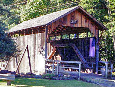
Built in: 1881
Bridge Length: 39'
County: Jackson
Photo by
Pat Cook
The Lost Creek Bridge, at 39
feet, is the shortest of all Oregon covered
bridges. Since 1979, the structure has been
closed to traffic with a concrete span handling
the few vehicles each day.
Oldest? Many Jackson
County residents, including Shirley Stone,
daughter of pioneer John Walch, claim the Lost
Creek Bridge to have been built as early as
1878-1881. If authenticated, this would make it
Oregon's oldest standing covered bridge.
Johnny Miller, the builder of the Lost Creek
Bridge, also roofed the nearby span at Lake
Creek in the 1880s, thus lending credence to a
sign nailed on the bridge: LOST CREEK BRIDGE,
BUILT ABOUT 1881.
The span may have been
partially or totally rebuilt in 1919, hence the
official construction date in that year.
Features of the bridge include the usual county
Queenpost design, a shingle roof and flying
buttress braces. The rough wooden flooring
consists of diagonal planking, and hand hewn
truss members provide structural stability.
A new roof was installed by local
residents in 1985. Portal boards were added in
1986, restoring the look of the span in 1920
before accommodations were made for log truck
traffic.
The Walch Memorial Wayside
Park abuts the bridge site. Descendants of John
and Marie Newsome Walch built and maintain the
park, which includes picnic tables, a bandstand,
cooking areas, an early 1900s outhouse, and
manicured flower gardens.
The
bridge was nearly lost in the 1964 Christmas
flood. As swirling waters and heavy debris
lashed at its piers, residents and concerned
bridge enthusiasts prayed during the night that
the bridge would be saved. According to a local
newspaper, the skies opened and the water
receded as morning came. The journalist
questioned, "Was the bridge saved by prayer?"
Location
World Guide# 37-15-03
Latitude: N42 22.81
Longitude: W122 34.77
Driving Directions
From
Eagle Point, continue southeast on Royal Avenue
to Highway 140. Alternately, travel east on
Highway 140 from Highway 62, Crater Lake
Highway. Continue on Highway 140 to Lake Creek
Loop Road. From Lake Creek Loop Road, travel
south through Lake Creek on South Fork Little
Butte Creek Road. Turn south on Lost Creek Road
and continue approximately one half mile. Lost
Creek Bridge is 4 miles south of Lake Creek
Information provided by: Covered Bridge
Society Of Southern Oregon.
Always Verify
Driving Instructions.
Add More Information!
We Can Add More Information to
this page, Click Here and supply
your text info and we will add it in!
SouthernOregon.com
does Not provide Directions and Info by phone.
BACK TO COVERED BRIDGES
This
is a general information page. All profile information on is
provided to users on an "as is" and "as available" basis without
warranty of any kind either express or implied. See terms
page if needed.