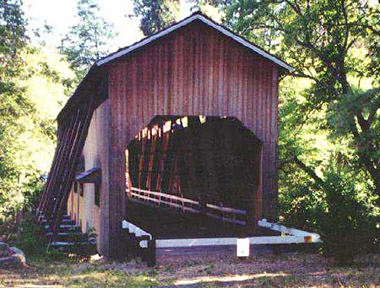
Built in: 1917
Bridge Length: 112'
County:
Jackson
Photo by
Pat Cook
The rustic, well-known covered
bridge spanning the Applegate River, just eight
miles from the California border, was built in
1917 by contractor Jason Hartman and his son
Wesley on land donated by Aldelbert "Deb" McKee.
The bridge was used
from 1917 to 1956, originally serving the mining
and logging traffic. In 1956, the bridge was
declared unsafe for vehicular traffic. The
combined efforts, in 1965, of the Talisman
Lodge, Knights of Pythias, Upper Applegate
Grange, and the Jackson County Court restored
the roof, thereby keeping the aging structure
open for pedestrian use.
Little
upkeep followed,
and by
the early 1980s County officials were worried
about the strength of the bridge.
During the summer of 1985,
more than $40,000 in labor and materials were
dedicated to repair the bridge and keep it open
for pedestrians. Jackson County officials then
announced that future County investment in the
bridge would be impractical, and has looked to
private efforts for ongoing preservation of the
McKee span.
The McKee Committee
was formed in January 1989 with the goal of
raising $25,000 for preservation and maintenance
of the span. By mid summer, a major portion of
the funds, or volunteer labor, had been
generated. Included in the final fund-raising
was the sale of memorabilia and the production
of an historic quilt featuring a bridge motif.
Features of the Mckee Bridge include a Howe
truss design, flying buttresses, open
daylighting windows at the roofline, and a
shingle roof.
Lindsay Applegate, for
whom the stream is named, prospected the area on
the way to the mines in California. The
discovery of prosperous mines caused a
north-south route to be developed in the area,
and the covered bridge was used as a rest stop,
until 1919, because it was halfway between
Jacksonville and the Blue Ledge Cooper Mine to
the south.
The McKee Picnic Ground, a
Rogue National Forest facility, is at the west
end of the bridge along the Applegate River.
Location
World Guide# 37-15-06
Latitude: N/A
Longitude: N/A
Driving Directions
From
Medford travel west on Highway 238 through
Jacksonville to Ruch. From Ruch head south on
Applegate Road for approximately 8.5 miles.
Always Verify
Driving Instructions.
Add More Information!
We Can Add More Information to
this page, Click Here and supply
your text info and we will add it in!
SouthernOregon.com
does Not provide Directions and Info by phone.
BACK TO COVERED BRIDGES
This
is a general information page. All profile information on is
provided to users on an "as is" and "as available" basis without
warranty of any kind either express or implied. See terms
page if needed.