An 1895 era photograph shows
the wagon bridge and adjacent railroad bridge,
both being covered. The wooden rail span was
replaced soon after.
Old timers recall the Pass
Creek Bridge provided excitement when a
horse-drawn wagon crashed through the floor
around 1920 while hauling supplies for a
Thanksgiving turkey shoot. Although the wagon
dropped below the decking, the only casualties
were the words uttered by the driver, the
drowning of turkeys and splashing of supplies
into the creek.
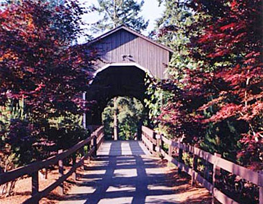
It is probable the
covered wagon bridge at this location was either
rebuilt or replaced in 1925, displacing the
earlier span. Holes in the lower chords indicate
that it may have been salvaged from another
bridge.
Today a concrete
bridge now crosses Pass Creek where the old
wooden structure once rested. In the fall of
1987, after the roof and siding of the covered
bridge were removed, a 90-ton crane lifted the
trusses and moved them one block away where the
structure was reassembled the following year.
The wooden bridge had been closed to traffic
since 1981, causing the handful of local
residents surrounding the span to maneuver under
a cramped railroad trestle to get to their
homes.
LocationWorld
Guide# 37-10-02
Latitude: N43.39.38
Longitude: W123.18.60
Driving Directions
Pass Creek Bridge is on 101 W A Ave, in
the city of Drain Oregon in Douglas County.
Drain, Oregon. From Highway 99 (West B Street)
in Drain, turn south onto 2nd Street and go one
block to West A Street. Located in the city of
Drain, behind Drain Civic Center at 205 W. A
Street. Driving
directions could vary depending on direction
your coming from.
Information provided by: Roofs Over Rivers,
by Bill and Nick Cockrell.
Always Verify
Driving Instructions.
Add More Information!
We Can Add More Information to
this page,
Click Here and supply
your text info and we will add it in!
SouthernOregon.com
does Not provide Directions and Info by phone.
BACK TO COVERED BRIDGESThis
is a general information page. All profile information on is
provided to users on an "as is" and "as available" basis without
warranty of any kind either express or implied. See
terms
page if needed.