This info may change so Call the Chamber
to verify this 541-947-6040
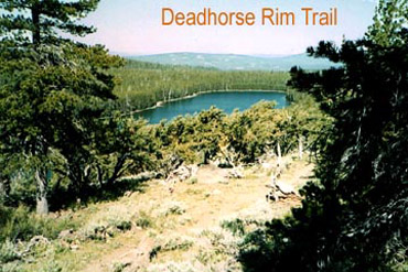
Dead Horse
Rim Trail: This trail accesses the
road-less country found in the vicinity of Dead
Horse Rim. It also accesses Dead Cow Trail, and
the Lakes Trail system. It travels through and
along a large upland meadow near the Lee Thomas
Trailhead and then ascends Dead Horse Rim
through stands of lodge pole pines and mature
mixed conifers. As it runs along the spine of
Dead Horse Rim scenic vistas of the Dead Horse
Creek drainage and the surrounding country are
offered. The trail currently dead ends on its
southern end at the National Forest boundary,
but plans are in the works to rectify this
situation.
Dead Cow Trail: This trail
provides a loop trail opportunity of about 6
miles in length from Dead Horse Lake down the
Dead Cow Creek drainage then via the Dead Horse
Rim Trail and Lakes Trail back to Dead Horse
Lake. The Dead Cow drainage contains an
abundance of wild flowers during the spring and
early summer. This is an interesting day-hike
loop opportunity passing through a variety of
high elevation environments.
Addition Information on Trails:
This
trail system offers a variety of interconnected
loops of various lengths between Campbell and
Dead Horse Lakes. There is a lower trail and an
upper trail and they are connected at their
eastern and western ends as well as by an
intertie trail approximately in the middle of
their reaches. This arrangement offers users
loop trips from five to nine miles long. The
Lakes Loop system is also connected to the Dead
Cow Trail #141, the Dead Horse Rim Trail #139
and the Cache Cabin Trail # 148 providing
approximately 24 miles of trails in this area
for Forest visitors.
Scenic vistas of
the lakes and the surrounding country are found
throughout this system, but particularly from
the heights of Campbell and Dead Horse Rims. On
a clear day the distant views from these lofty
viewpoints are spectacular and limited only by
the curvature of the Earth. The upper Lakes Loop
Trail and Dead Horse Rim Trail also access one
of the largest stands of sub-alpine white-bark
pine in the Pacific Northwest. The trail is well
signed at all junctions and has vertically
aligned rectangular blazes for reassurance
markers.
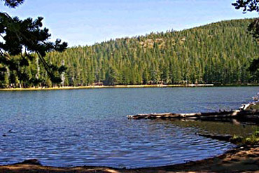
Lakes Loop Trail #140: Total
length: 9 miles
Elevation: Low 7220 ft., High
8020 ft., Vertical difference, 800 ft.
Difficulty Level: Easy to Moderate
How
to get there:From Paisley Ranger
District Office:
Go 1/2 mile north on Highway
31, and turn left on Mill Street. Mill Street
becomes Forest Road 33 at the "Y" junction. Stay
to the left and continue on Forest Road 33 for
20 miles. At the "T" intersection with paved
road 28, stay to the right. Follow Forest Road
28 for 11 miles, watch for the well marked turn
to Campbell/Deadhorse Lakes, take a left at the
junction with Forest Road 033. Three miles on
this graveled road will lead to the Deadhorse
Lake Campground entrance.
From
Lakeview:Take Highway 140 West 3
miles, then turn right onto County Road 2-16. Go
on County Road 2-16 for 5 miles. Turn left onto
County Road 2-16A and within 2 miles, you will
be on Forest Road 28. Follow Forest Road 28 for
28 miles, watch for the well marked turn to
Campbell Lake, take a left at the junction with
Forest Road 033. Three miles on this graveled
road will lead to the Campbell Lake Campground
entrance.
F
rom Bly Ranger
District Office:Head east on
Highway 140 for 1/2 mile to the Campbell Road,
you should see the sign. Turn left onto the
Campbell Road and go for 1/2 mile to Forest Road
34. Turn right and drive 25 miles to Forest Road
28. Turn left onto Forest Road 28 and go for 6
miles. Watch for the well marked turn to
Campbell/Deadhorse Lakes, take a left at the
junction with Forest Road 033. Three miles on
this graveled road will lead to the Deadhorse
Lake Campground entrance.
T
o US
Forest Service-Campgrounds fees, dates, hours:
SEE WEBSITEFor More Info o
Call the Chamber to verify this 541-947-6040( SouthernOregon.com does not specify
fees/ dates/hours/info )
Add More Information!
We Can Add More Information to
this page,
Click Here and supply
your text info and we will add it in!
BACK TO LAKES PAGE This
is a general information page. All lake information on is
provided to users on an "as is" and "as available" basis without
warranty of any kind either express or implied.
SouthernOregon.com is not responsible for any change in lake
information, conditions, amenities, misprint, hours or
directions. See
terms page to read more user details.